Bay Area Vital Signs: Freeway Congestion Hits New Record
The Metropolitan Transportation Commission (MTC) today unveiled its yearly analysis of Bay Area freeway congestion, with new data showing congestion-related delays during weekday commute periods climbed 9 percent to a record average of 3.5 minutes per commuter in 2016 from 3.2 minutes a year earlier. This marks the fourth consecutive year that weekday congestion around the region has reached a new high, and reflects an increase of more than 80 percent over the 1.9-minutes-per-commuter-per-day figure registered in the recession year of 2010. MTC defines “congested delay” as the time spent in traffic moving at speeds of less than 35 mph.
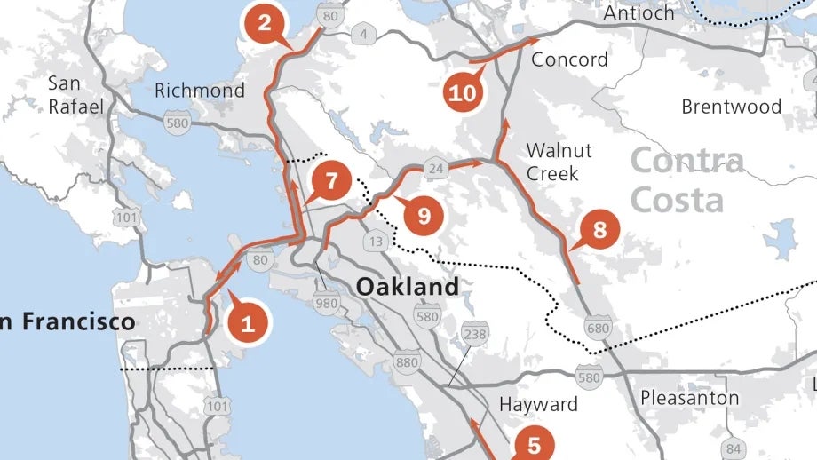
Topping the list of the Bay Area’s most congested freeway segments for the second year in a row is the afternoon crawl on northbound and eastbound on U.S. 101 and Interstate 80 from the I-280 interchange in San Francisco to the Bay Bridge’s Yerba Buena Island Tunnel. Retaining the #2 spot on the Top 10 list is the westbound I-80 drive from State Route 4 in Hercules to Fremont Street in San Francisco, with congested conditions typically extending through at least part of this corridor from 5:25 a.m. to 6:55 p.m. This is the only segment among the region’s 10 most congested corridors on which congestion is not routinely interrupted by a mid-day break, and the only Top 10 route to involve a morning commute.
The remainder of the Top 10 list includes the afternoon slog on southbound U.S. 101 from Mountain View to San Jose, which held steady in the #3 position; the afternoon commute on northbound I-680 from the South Mission Blvd./State Route 262 interchange in Fremont to Andrade Road in Sunol, which climbed two spots to #4; the afternoon drive on northbound I-880 from Mowry Ave. in Fremont to Winton Ave. in Hayward, which rose to #5 from #8 in 2015; the southbound afternoon commute on I-280 from Foothill Expressway in Los Altos to downtown San Jose, which moved up to #6 from #12 a year earlier; the afternoon drive on eastbound I-80 from West Grand Ave. in Oakland to Gilman Street in Berkeley, which slipped three spots to #7; the afternoon drive on northbound I-680 from San Ramon to Pleasant Hill, which rose to #8 from #11 in 2015; the afternoon commute along eastbound State Route 24 from Oakland to Walnut Creek, which moved up one spot to #9; and the afternoon drive on State Route 4 from Morello Ave. in Martinez to Port Chicago Highway in Concord, which rose to #10 from #16.
“Eight of the top 10 most crowded commutes are routes to or from the Bay Bridge or Silicon Valley,“ observed MTC Chair and Rohnert Park Mayor Jake Mackenzie. “The good news is that this shows the continuing strength of the South Bay and San Francisco job markets. The bad news is that it shows how hard it is to balance where the region’s job centers are located and where comparatively affordable housing can be found.”
Alameda County Supervisor and MTC Vice Chair Scott Haggerty noted that half of the Bay Area’s 10 most congested freeway corridors — and roughly one-third of the top 50 — are in Alameda County. "I think we need to look for marginal gains everywhere we can — ramp metering, express lanes, they all matter. These smart investments have certainly helped in the I-580 Corridor and will help leverage our bigger investments in rail connectivity and dollars for highway infrastructure improvements that will continue to improve the commute through the Tri Valley. I’m hopeful we can also see 880 and northbound 680 drop off the Top 10 list as new Express Lane projects in these corridors come on line in the next couple years.”
The congestion data is one of several transportation indicators updated today as part of MTC’s web-based Vital Signs performance-monitoring initiative (www.vitalsigns.mtc.ca.gov).
Other newly updated Vital Signs include:
- Bridge Condition: Bay Area bridges (including those owned by cities and counties as well as state-owned highway bridges) are in better shape than ever, with the share identified as structurally deficient falling to 7 percent in 2016 from more than 30 percent a decade ago. The Bay Area has made more progress in bridge maintenance than any of nation’s other Top 10 metro areas;
- Commute Mode Choice: The share of Bay Area commuters using public transit ticked up slightly to 12 percent in 2015, the fifth straight year of increase;
- Commute Time: The average commute time for a typical Bay Area worker rose to a new record of 31 minutes in 2015;
- Inter-regional Traffic: Average daily traffic volumes between the Bay Area and the Sacramento region hit a new high of more than 170,000 vehicles in 2015;
- Miles Traveled in Congestion: 94 percent of the miles driven on Bay Area freeways in 2016 occurred in free-flow or moderate-flow conditions;
- Travel Time Reliability: Despite rising congestion, travel times during peak periods have seen minimal changes in day-to-day reliability since 2010;
- Transit Ridership: Regional transit ridership increased for the fifth year in a row in 2016 to an average of 1.8 million boardings each weekday;
- Transit Cost-Effectiveness: As Bay Area residents take more train trips and fewer bus trips, per-boarding costs for BART, Caltrain and other rail transit operators continue to fall while those for bus operators are on the rise;
- Daily Miles Traveled: The Bay Area’s per capita vehicle-miles traveled have remained stable at about 23 miles per day since 2005; but due to population growth, total daily vehicle-miles traveled hit a record high of 172 million in 2015;
MTC is the transportation planning, financing and coordinating agency for the nine-county San Francisco Bay Area.

