Bay Area Vision Zero Working Group
Vision Zero is an initiative to reduce the Bay Area’s annual roadway injuries and fatalities to zero. This MTC-led working group strives to make the region’s streets safer for everyone, especially pedestrians and bicyclists.
Over 400 fatalities and 1,500 serious injuries occur on the Bay Area’s local streets and roads each year. As the population grows and the total vehicle miles traveled increase, these numbers could rise if regional and local policies remain unchanged.
The Bay Area Vision Zero Working Group is an MTC-led panel of officials working toward a shared goal of making the region’s streets safer for everyone.
Members come from cities, counties, transit agencies, universities and advocacy groups.
MTC will also use the group to help roll out technical assistance efforts.
Upcoming Meetings
The group meets approximately four times per year. Email bayviz@bayareametro.gov to be added to the mailing list.
MTC is working to reduce deaths and injuries from traffic collisions by supporting Regional Safety (Vision Zero) initiatives.
Staff Contacts
For assistance, including information on upcoming meetings and joining the email list, please contact:
Shruti Hari, Funding Policy & Programs
Phone: 415-778-5360
Email: shari@bayareametro.gov
Bryan Redmond, Funding Policy & Programs
Phone: 415-778-5311
Email: bredmond@bayareametro.gov
A Regional Approach
While several Bay Area cities (San Francisco, Fremont, Oakland, San Jose, Berkeley and Menlo Park) have already adopted Vision Zero policies to reduce fatalities and injuries, MTC encourages further action around the region.
MTC is required to adopt safety performance measures and targets, and to provide resources to cities and counties to support regional safety goals. A regional approach can promote improved safety and eliminate some duplication of costs among cities and counties. This allows local governments to redirect their limited dollars toward implementing new safety projects and policies.
MTC’s Role
MTC provides data and offers technical assistance to local governments to supplement existing Vision Zero efforts.
Assistance includes:
- Reliable safety data
- Analytical toolkits
- Technical expertise to enhance safety
- Funding advocacy
- Help to prepare Local Road Safety Plans (required by Caltrans as a condition of Highway Safety Improvement Plan funding)
MTC’s regional focus also can help coordinate safety projects spanning across city or county lines.
The MTC Regional Safety/Vision Zero Policy establishes a framework to support equitable and data-driven action to eliminate traffic deaths and serious vehicular injuries in the Bay Area by 2030.
The Regional Safety Policy establishes a framework to guide MTC staff in working towards the policy goals:
- Provide regional leadership to promote safety; engaging and incentivizing leadership across jurisdictions; working toward aligning funding policy with safety goals.
- Apply a data-driven approach to inform safety policy and strategic use of available funds and resources. Regional safety data will be housed at MTC so local jurisdictions can benefit from consistent and reliable data.
- Promote equity in regional safety policies by considering and analyzing impacts on communities of concern and protecting vulnerable roadway users, such as pedestrians and bicyclists.
- Support beneficial safety policies and legislation targeting evidence-based solutions to safety problems.
- Engage key regional stakeholders in safety policy development, implementation and collaboration on safety best practices. Provide education and technical assistance within budgetary constraints.
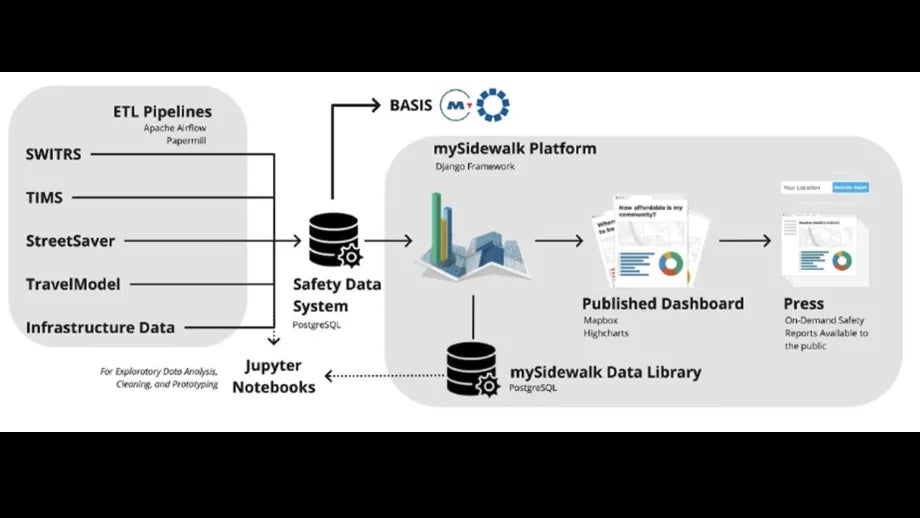
MTC’s Safety Data System, BayVIZ, will improve cities’ and counties’ access to safety-related data and analysis tools, so they can develop tailored traffic safety plans and identify countermeasures to reduce traffic fatalities.
This flexible system integrates information about crashes, infrastructure, equity and demographics, as well as additional data that become available over time. This integration facilitates safety analyses that cities can use that fits with their unique priorities and challenges. Local jurisdictions can access data from individual intersections to longer transportation corridors, and to identify larger regional trends.


