Bay Skyway
A team is working to extend both ends of the San Francisco-Oakland Bay Bridge East Span Path into a broader network called the "Bay Skyway" that will link Oakland and the greater East Bay with Treasure Island and downtown San Francisco.
We Want to Hear From You
Every year, thousands of residents and visitors enjoy the path on the East Span of the Bay Bridge, a 15-foot-wide walking and biking path with panoramic views of San Francisco Bay. The path joins Berkeley and Emeryville with Yerba Buena Island with a bus connection and private ferry service to downtown San Francisco. The Bay Skyway project will extend the path in both directions, linking Oakland and the greater East Bay with Treasure Island and downtown San Francisco.
Building the Complete Bay Bridge Path
Creating the complete car-free path between San Francisco and the East Bay will take several significant steps.
Work on the first piece of the puzzle – known as the Multimodal Bay Skyway – is already underway and expected to be complete by 2031. It will connect the West Oakland Community all the way to Treasure Island. This part of the project is called multimodal because the final connection for the full journey to San Francisco will require taking transit (bus or ferry) from Treasure Island to downtown San Francisco.
The second piece of the puzzle – a bicycle/pedestrian path on the West Span of the San Francisco-Oakland Bay Bridge – is in the early planning stages.
About the Bay Skyway
Multimodal Bay Skyway Project Details
The Multimodal Bay Skyway is made up of two key projects—the Full West Oakland Link and the Full Yerba Buena Island Multi-Use Pathway—which together will extend both ends of the existing San Francisco-Oakland Bay Bridge East Span Path. Both projects are currently in the design phase with initial segments planned to open by 2029.
- The West Oakland Link will extend the east end of the East Span path further to the east by constructing the missing connection to West Oakland, connecting with planned protected bike lanes on Grand Avenue to Downtown Oakland.
- The Yerba Buena Island Multi-Use Pathway will extend the East Span path west to the Treasure Island intermodal hub. From there, travelers will be able to take a ferry or expedited bus into downtown San Francisco.
- The electric ferry will connect Treasure Island and the San Francisco Ferry Building, with plans to extend service to Mission Bay in the future. Frequent electric ferry service intervals of 15-minute are not expected until 2030 or later.
- Buses will operate on a new one-way bus-only lane and on ramp between Treasure Island and the Bay Bridge West Span that will decrease bus travel time to downtown San Francisco.
Full Project Area Map
The Multimodal Bay Skyway will connect the East Bay with Treasure Island by extending the existing bicycle and pedestrian pathway on the East Span of the Bay Bridge (solid pink line on the map below) both eastward and westward. It will also improve existing transit connections between Treasure Island and San Francisco. The West Oakland Link will continue the pathway into Oakland, while the Yerba Buena Island Multi-Use Pathway will guide users to Treasure Island's bus and ferry terminal hub. From there, travelers can choose between a ride to downtown San Francisco via electric ferry service or an express bus operating in a dedicated congestion-free transit-only lane.

Bay Skyway Project Benefits
- Sustainability: Adds a new sustainable and low-cost travel mode along the Bay Bridge corridor, increasing capacity without increasing vehicle miles traveled (VMT), greenhouse gas emissions or air pollution. By connecting a Transbay pathway with an electric ferry network, the project supports car-free development and enables new Treasure Island residents to establish sustainable transportation options starting on move-in day.
- Access: Provides a connection for bicycle/e-bike/micromobility users going between San Francisco and Oakland, which are two cities with the lowest car ownership rates in California. It also provides 20,000 future residents of Treasure Island with improved transit and bicycle access to the East Bay and regional rail such as BART, Capitol Corridor and Amtrak.
- Equity Priority Communities: The Bay Skyway will provide access to high-quality jobs at the Port of Oakland and in downtown San Francisco, while providing an affordable transportation option for residents of equity priority communities on both sides of the Bay.
- Car-Free Housing: In the next decade, significant housing developments are planned in the areas around downtown San Francisco and adjacent to the Multimodal Bay Skyway. Projects include 8,000 units on Treasure Island, 5,000 in West Oakland and 29,000 in downtown Oakland, including thousands of affordable homes.
Part of the Bay Trail
The Bay Skyway is a critical section of the San Francisco Bay Trail which, when complete, will give hikers, joggers, bicyclists, skaters and wheelchair users access to more than 500 miles of trails encircling the bay. With the rapid adoption of electric bicycles (e-bikes), the Bay Skyway will also provide an alternative for Bay Area residents to cross the Bay without adding to roadway or transit congestion.
Part of Plan Bay Area 2050+
The Bay Skyway is included in Plan Bay Area 2050+ as part of the "Build Complete Streets Network" strategy to promote walking, biking and small electric micromobility vehicles (such as e-scooters) throughout the Bay Area.
Partnership
MTC, the Bay Area Toll Authority (BATA), Caltrans District 4, San Francisco County Transportation Authority (SFCTA), Treasure Island Mobility Management Agency (TIMMA), Alameda County Transportation Commission and San Francisco Bay Ferry are working on several projects in two phases to extend the path and connect downtown San Francisco and the East Bay.
Multimodal Bay Skyway Phase One: Interim West Oakland Link
Multimodal Bay Skyway Phase One
About $100 million has been secured by MTC and SFCTA to construct the interim Multimodal Bay Skyway projects that include the interim West Oakland Link, the interim Yerba Buena Island Multi-Use Pathway and electric ferry charging infrastructure. The full buildout of the West Oakland Link and Yerba Buena Island Multi-Use Pathway will be completed when funding is secured.
Timeline & Funding of Interim Projects
The Interim West Oakland Link (WOL) is in the detailed design phase with construction on the westernmost portion. In the near term, the project will rely on another MTC project — Bay Bridge Forward West Grand Avenue Bus and High Occupancy Vehicle Lane Phase 2 — to provide access sooner. The Bay Bridge Forward project includes the construction of a pedestrian and bicycle path connecting the eastern end of the WOL’s western touchdown and the West Grand Avenue/Mandela Parkway intersection. Construction of the Bay Bridge Forward path is expected to start and be completed in 2027. This path will not be impacted during the construction of the remaining portions of the interim WOL, which is anticipated to be completed by 2029. The full West Oakland Link will be constructed once funding is secured.
The Interim Yerba Buena Island Multi-Use Pathway (Interim YBI MUP) is currently under construction, expected to be complete in 2028, except for one section that includes a spiral loop ramp designed to connect the East Path landing with the Full YBI MUP. Until funding is secured for the spiral loop ramp, westbound bicyclists will continue to use Macalla Road on improved protected bike lanes. Eastbound bicyclists will use the interim YBI MUP and a temporary connector at the location where the spiral loop ramp will be. Pedestrians will continue to use Macalla Road in both directions until the spiral loop ramp is built.
Electric ferry service is planned to begin in 2027 with connections to downtown San Francisco, and future service to Mission Bay is expected.

Multimodal Bay Skyway Phase Two: Bay Bridge West Span
Bay Bridge West Span Path: Project Overview
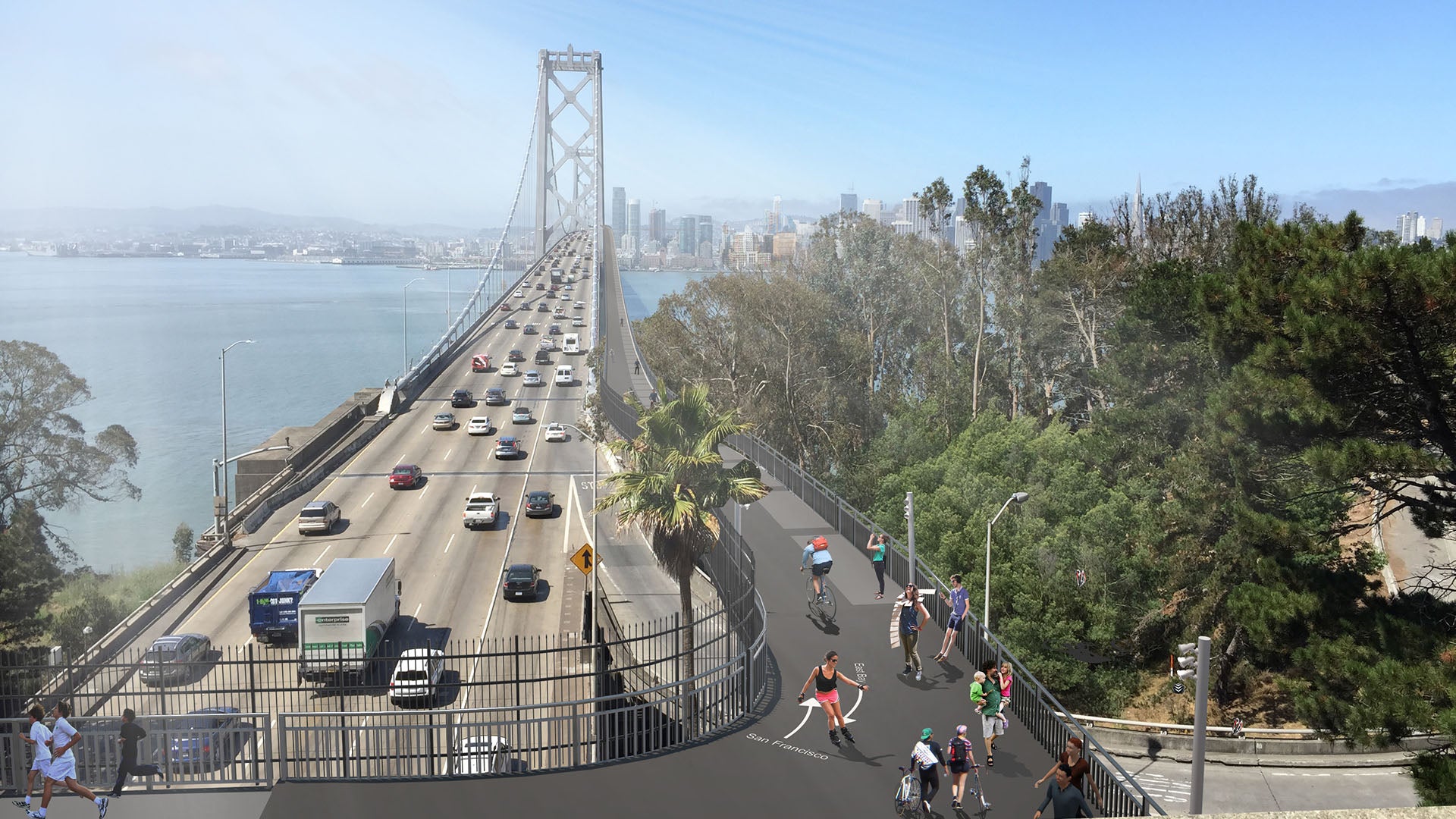
The Bay Skyway Phase Two project will construct a bicycle and pedestrian pathway on the Bay Bridge West Span, which will allow a continuous route to walk, bike and e-bike between the East Bay and downtown San Francisco. The path will have the capacity to carry 7,500 bicycle trips and 4,500 people walking per hour across the Bay. This project will build upon the infrastructure developed through the Multimodal Bay Skyway, connecting the West Span path to thousands of new residents on Treasure Island, the existing Bay Bridge East Span path, and into Oakland via the West Oakland Link. The next major milestone is completing the State and Federal environmental analyses, which can be finalized as early as 2027.
The Bay Skyway will help shift transbay trips to biking, e-biking, and other micromobility options. This will reduce congestion in the transbay corridor and reduce greenhouse gas emissions and air pollution while providing low-cost transportation options for Bay Area residents.
West Span Path Design
In 2018, alternative designs for a path on the Bay Bridge West Span were first presented to the public. As a result of this outreach and professional judgment, a design was chosen for a path on the north side of the bridge. This path will touch down on Essex Street in downtown San Francisco and on Yerba Buena Island, where it will connect to Treasure Island to the existing Bay Bridge East Span path via the Yerba Buena Island Multi-Use Pathway.

West Span Path Video
Watch the video to learn more about the proposed West Span Path.
Funding Challenges
The biggest challenge for the West Span Path project is securing funding. The cost is expected to be in the hundreds of millions of dollars, and no funding sources have been identified yet. State and Federal environmental analysis, the next step in the Phase 2 project, may be completed in 2027. If funding is secured, Phase 2 of the project could be completed as early as 2034.
Design Challenges
To move forward, the project must address several design issues including: safety during earthquakes, withstanding strong winds, providing access for maintenance crews, and maintaining enough clearance for shipping traffic.
Staff Contact
Gavin Lohry, Bay Skyway Program Coordinator
Phone: 415-778-6676
Email: glohry@bayareametro.gov