Bay Skyway
A team is working to extend both ends of the San Francisco-Oakland Bay Bridge East Span Path into a broader network called the "Bay Skyway" that it links Oakland and the greater East Bay with both Treasure Island and downtown San Francisco.
Every year, thousands of residents and visitors enjoy the path on the East Span of the Bay Bridge, a 15-foot-wide walking and biking path with panoramic views of San Francisco Bay that joins Berkeley and Emeryville with Yerba Buena Island. The Bay Skyway project will extend the path in both directions, linking Oakland and the greater East Bay with Treasure Island and downtown San Francisco.
The Bay Skyway is a critical segment of the San Francisco Bay Trail which, when complete, will give hikers, joggers, bicyclists, skaters and wheelchair users access to more than 500 miles of trails encircling the bay. With the rapid adoption of electric bicycles (e-bikes), the Bay Skyway will also provide an alternative for Bay Area residents to cross the Bay without adding to roadway or transit congestion.
The Bay Skyway is included in Plan Bay Area 2050 as part of the "Build Complete Streets Network" strategy to promote walking, biking and small electric micromobility vehicles (such as e-scooters) throughout the Bay Area.
The Bay Area Toll Authority (BATA), Caltrans District 4, San Francisco County Transportation Authority and Alameda County Transportation Commission are working on several projects in two phases to extend the path and connect downtown San Francisco and the East Bay.
Bay Skyway Current Projects: Phase One
Bay Skyway Phase One is made up of two key projects, which are both currently undergoing design and are planned to open in 2028.
- The West Oakland Link will extend the existing San Francisco-Oakland Bay Bridge East Span Path further to the east by constructing the missing connection to West Oakland, connecting with planned protected bike lanes on Grand Avenue to Downtown Oakland.
- The Yerba Buena Island multi-use path will connect the Bay Bridge East Span path to new electric ferry service between Treasure Island and downtown San Francisco. (There is interim, diesel-powered limited-schedule ferry service to serve the current residents of Treasure Island. This will remain operable until the new more frequent electric service begins in 2025.)
Details of Bay Skyway Current Projects
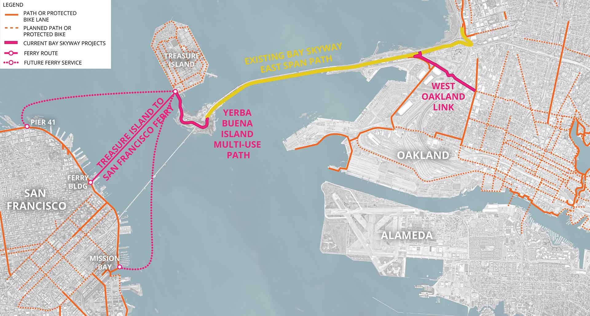
Map of Current Projects

In this map, the yellow line indicates the existing bicycle/pedestrian pathway on the East Span of the Bay Bridge. Orange lines in San Francisco and the East Bay indicate existing bicycle network paths. The pink line in Oakland shows the proposed West Oakland Link path. The Yerba Buena Island multi-use path is indicated with the pink line that connects the west end of the East Span path with the Treasure Island Ferry. The pink lines in the water between Treasure Island and San Francisco indicate present and future ferry routes.
Timeline and Funding Opportunities
The West Oakland Link and Yerba Buena Island multi-use path are both in the detailed design phase with construction to start in 2025 or 2026 and opening planned for 2028. Electric ferry service is planned to begin in 2025.
Current Bay Skyway projects are estimated to cost approximately $202 million to construct, including the West Oakland Link, the Yerba Buena Island path and ferry electric charging infrastructure.
Competitive California state grants, including the Active Transportation Program and the Senate Bill 1 Solutions for Congested Corridors Program and Local Partnership Program are being pursued to fund these projects, along with other potential funding sources.
Bay Skyway: Phase Two on the Bay Bridge West Span
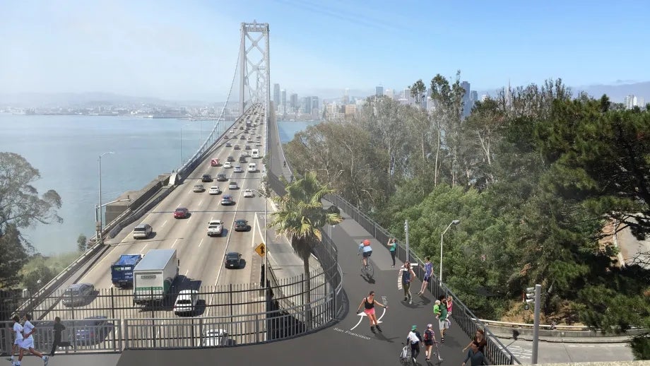
The Bay Skyway Phase Two project will construct a bicycle and pedestrian pathway on the Bay Bridge West Span, which will allow a continuous route to walk, bike and e-bike between the East Bay and San Francisco. This project will rely on Phase One to connect the West Span path to the thousands of new residents on Treasure Island and to downtown Oakland through the West Oakland Link.
The Bay Skyway will help shift transbay trips to walking, biking and other micromobility (e-scooter, e-skateboard, etc.) options, which will reduce congestion and greenhouse gas emissions, while providing low-cost transportation options for Bay Area residents.
West Span Path Details
West Span Path Design
Contractors submitted designs in 2016 and shared them with the public in 2018. A design was chosen for a path on the north side of the West Span of the Bay Bridge. This path will end in San Francisco at Essex Street.
On Yerba Buena Island, the East Span and West Span paths will connect to a new pathway parallel to Hillcrest Road.
West Span Path Video
Watch the video to learn more about the proposed West Span Path.
Funding Challenges
Paying for the West Span Path is the project’s biggest challenge. Estimated costs for a project like this run into the hundreds of millions of dollars and no source of funding has yet been identified. State and Federal environmental analysis, the next step in the Phase 2 project, may be completed in 2026. If funding is secured, Phase 2 could open as early as 2033.
Design Challenges
Design problems to solve so that the project can move forward include earthquake safety, strong winds, access for maintenance crews, maintaining boat clearance, connections to existing bicycle/pedestrian network and environmental impacts.
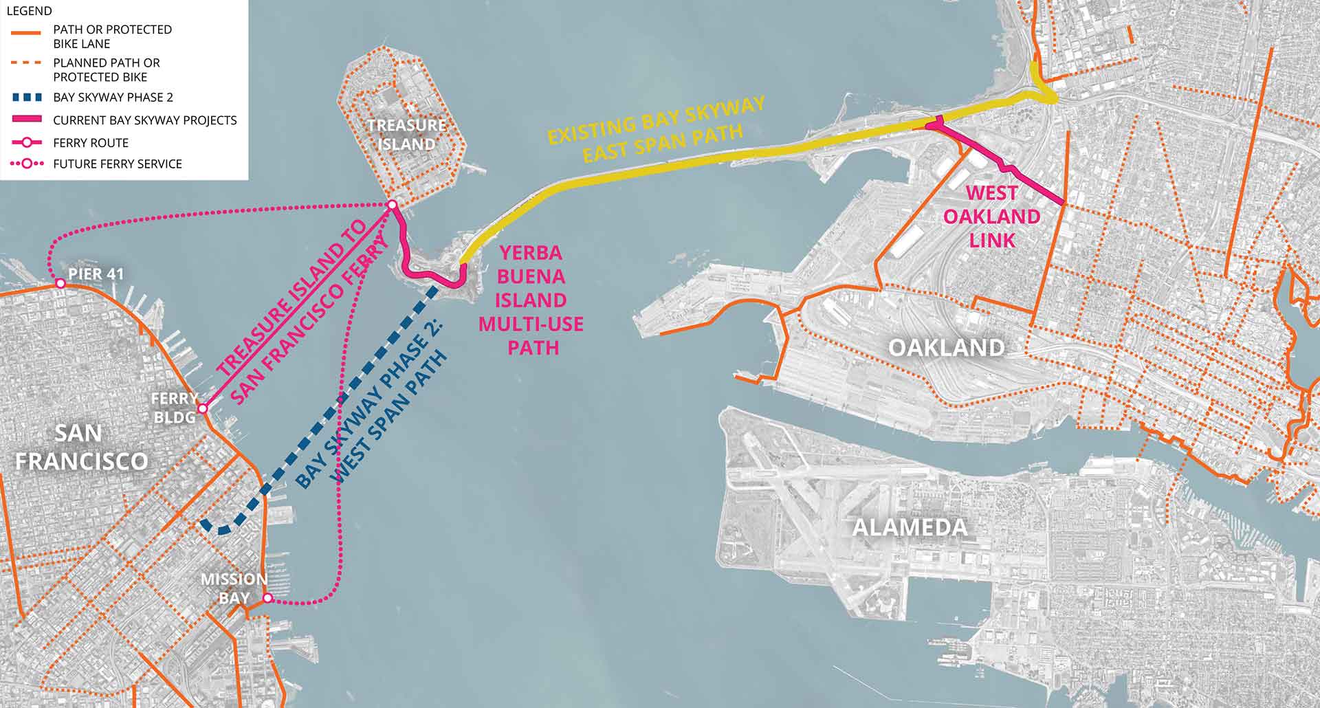
Map of Bay Skyway Phase Two: West Span Path
 In this map, the blue line indicates the proposed Bay Skyway Phase 2: West Span Path. The yellow line indicates the existing bicycle/pedestrian pathway on the East Span of the Bay Bridge. Orange lines in San Francisco and the East Bay indicate existing bicycle network paths. The pink line in Oakland shows the proposed West Oakland Link path. The Yerba Buena Island multi-use path is indicated with the pink line that connects the west end of the East Span path with the Treasure Island Ferry. The pink lines in the water between Treasure Island and San Francisco indicate present and future ferry routes.
Staff Contact
Gavin Lohry, BATA Project Manager, Transportation Planning and Operations
Phone: 415-778-6676
Email: glohry@bayareametro.gov

