Dumbarton Bridge
The original Dumbarton Bridge was the first vehicular crossing over San Francisco Bay proper. It now provides three lanes in each direction, as well as a bicycle/pedestrian path.
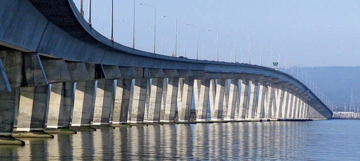
The original Dumbarton Bridge was the first vehicular crossing over San Francisco Bay proper. It is also known as State Route 84, located between San Mateo and Alameda counties near Newark and East Palo Alto.
The bridge was rebuilt in 1984 for safety and traffic congestion reasons. The Dumbarton now provides three lanes in each direction, separated by a concrete barrier, as well as a bicycle/pedestrian path.
The western approach to the Dumbarton Bridge from U.S. 101 — the Bayfront Expressway — was widened from four lanes to six lanes as part of the Bay Area Toll Authority (BATA)'s Regional Measure 1 program. Widening of the expressway was completed two months ahead of schedule in July 2003.
How many bikes and pedestrians have crossed the Dumbarton Bridge since April 2016? What times of day do most bikes and pedestrians make the trip?

After Caltrans and BATA evaluated the seismic safety of the Dumbarton Bridge, a 2013 seismic retrofit project was done to make the bridge safer during a major earthquake.


Bridge Facts At-A-Glance
| Location: | State Route 84 between San Mateo and Alameda counties near Newark and East Palo Alto |
|---|---|
| Structure: | Steel box girder and pre-stressed concrete approach spans |
| Length: | Total length 1.6 miles |
| Vertical Clearance: | 85 feet |
| Channel Span: | 340 feet |
| Opened: |
|
| Cost: |
|
| Auto Toll: | $8.50 |
| Carpools: | $4.25 |
| Collection: | One-way, westbound in Newark |
| Traffic Lanes: | Three in each direction |
| FY 2022-23 Total Toll-Paid Vehicles: | 9,617,023 |
| FY 2022-23 Total Tolls Collected: | $62,019,204 |
| Bridge Path Counter Data: | Access bicycle and pedestrian counter data |
The Dumbarton Bridge carries more than 81,000 vehicles a day. MTC initiated the Dumbarton Bridge West Approach + Adjacent Communities Resilience Study to address the threat of sea level rise on the western approach.
See vehicle traffic and public transit ridership numbers from 2019 to the present.
Regional Measure 1, approved by Bay Area voters in 1988, raised tolls on the Bay Area’s seven state-owned toll bridges to fund bridge improvements and parkway construction.