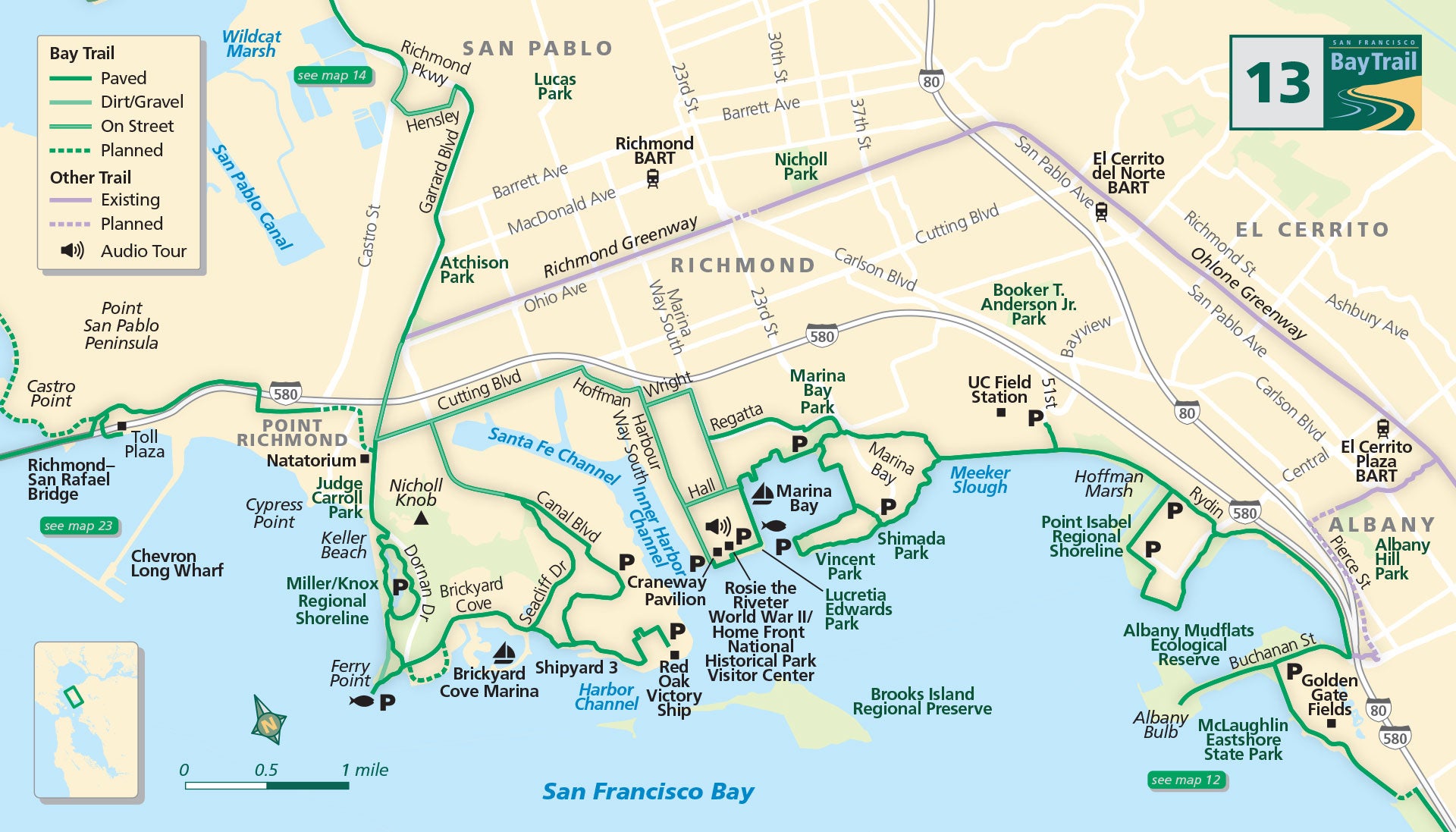
Map 13 — Albany to Richmond
Point Isabel Regional Shoreline
Making your way through the northern reaches of McLaughlin Eastshore State Park, round the edge of Golden Gate Fields to the Albany Mudflats Ecological Reserve.
Visit Albany Bulb for its spectacular views of the bay and found-art exhibits. The Bay Trail continues north, squeezing between Interstate 580 and the mudflats en route to Richmond.
At Central Avenue, the trail splits into two routes before reaching Point Isabel Regional Shoreline. Take the shoreline route for bay views and the inland route for a more direct connection. You’ll have guaranteed sightings of cavorting canines running through this popular dog park.
Continue along the trail between the bay and Hoffman Marsh to reach another trail junction at Meeker Slough. Take in the expansive views of the bay and wetlands rich with shorebird activity.
Marina Bay
Follow the inland route along the slough to Marina Bay Park and the Rosie the Riveter World War II/Home Front National Historical Park art sculpture and continue along Regatta Boulevard using city streets to reach the bike lanes on Cutting Boulevard.
Take the shoreline route for expansive bay views and visits to Shimada Park, Vincent Park and Lucretia Edwards Park as well as Marina Bay Park and the Rosie the Riveter World War II/Home Front National Historical Park art sculpture.
Visit the Rosie the Riveter World War II/Home Front National Historical Park Visitor Center located next to the historic Craneway Pavilion and follow Harbour Way South to Cutting Boulevard.
Miller Knox Regional Shoreline
The Ferry Point Loop Trail begins at Canal Boulevard and extends along the shoreline to Brickyard Cove Road, through Miller Knox Regional Shoreline and into the Ferry Point Tunnel arriving at Point Richmond.
Seacliff Drive provides a shortcut to Brickyard Cove Road. Along the loop trail, visit historic Shipyard 3 on the paved path through the Port of Richmond to the Red Oak Victory Ship, and stop to gaze at the San Francisco skyline.
Brooks Island Regional Preserve, a protected nature preserve, is visible from the shoreline. Point Richmond is a great place to stop for lunch before continuing across the Richmond-San Rafael Bridge Path to Marin County, or continue north along Garrard Boulevard to connect to the path along Richmond Parkway.
Albany Bulb (Albany)
As you walk on the trails at the Albany Bulb, you’ll find evidence of the wild history of the Bulb and discover some of the urban art created by local artists out of the debris at this former trash dump.
Point Isabel Regional Shoreline (Richmond)
Welcome to dog heaven! Canines are everywhere at this shoreline park. While your dog is busy making new furry friends, you can enjoy the spectacular views of the Golden Gate Bridge and the bay. You can also get your dog washed and groomed at the park while you grab a coffee and snack from the café.
Rosie the Riveter Visitor Center (Richmond)
Located along the Bay Trail, this National Park explores and honors the efforts and sacrifices of American civilians on the World War II home front. The museum details how they lived and worked — highlighting the role of women and African-Americans in making Richmond one of the most productive industrial sites during the war.
Miller Knox Regional Shoreline (Richmond)
This expansive 307-acre park boasts nine separate picnic areas with BBQs that can be reserved and accommodate 50 to 200 people. The park is great for big family gatherings, birthday parties and social club events. There’s also a volleyball and horseshoe court.

