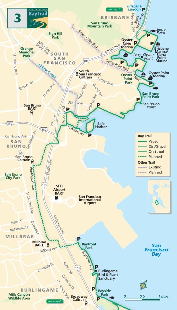
Map 3 — Brisbane Lagoon to Bayside Park
Brisbane Lagoon & South San Francisco
With San Bruno Mountain looming above, begin exploring northern San Mateo County at the Brisbane Lagoon along Sierra Point Parkway. The lagoon was a cove before Highway 101 was constructed, and it continues to support thriving bird and fish populations.
Travel along bike lanes under the highway and follow the perimeter trail to Sierra Point, past the Brisbane Fishing Pier to the Brisbane and Sierra Point marinas.
Continuing south along the edge of an office park, curve around Oyster Cove Marina, where old piers bear witness to a century of enterprise. Ships for World Wars I and II were built here, and piping was manufactured for the Hetch Hetchy, Grand Coulee, Shasta and Folsom dams.
San Bruno
The trail continues through Oyster Point Park and Oyster Point Marina, past San Bruno Point Park, the former site of one of the largest Chinese fishing camps on the bay, and across Colma Creek, spanned by a bicycle/pedestrian bridge. The path continues adjacent to Airport Boulevard and along North Access Road.
Visit an enjoyable trail loop around a bus service facility at Safe Harbor and a surprising place to view wildlife. On its western side, a vibrant marsh invites shorebirds and ducks to feed.
Millbrae
The Bay Trail is not yet complete around San Francisco International Airport.
Aspiring pilots will enjoy the best place to view airplane landings and takeoffs at Bayfront Park in Millbrae. From the park, follow the paved trail south as it parallels the shoreline, edged by hotels and businesses.
Burlingame
Continue south past the Burlingame Bird & Plant Sanctuary. A trail gap in this area requires bicyclists and pedestrians to use Bayshore Highway for a short stretch.
When you reach Bayside Park, you’ll see lighted fields for soccer and baseball, a playground, a dog park and lawns. Across the street on the bay is a small public fishing shore.
Colma Creek Public Shore (South San Francisco)
This marsh at the end of Colma Creek is a busy feeding zone for shorebirds and ducks, despite its proximity to Highway 101 and San Francisco International Airport. Look for activity along the marsh islands at low tide.
Bayside Park (Burlingame)
This 3/4-acre park is a great place for dogs to socialize. The dog exercise area is over 570 feet in length, allowing even large dogs to run to their hearts’ content.
Sierra Point to Oyster Point (Brisbane and South San Francisco)
Walking the 4 miles along this paved trail between two marinas brings you back in time to a place where oysters were farmed and ships were built along the edge of a calm inlet called Oyster Cove.

