Richmond-San Rafael Bridge Access Improvements
The Bay Area Toll Authority (BATA) funds and coordinates projects to ease congestion and make bicycle and pedestrian traffic safer along the Interstate 580 Richmond-San Rafael corridor.
Reducing Congestion and Increasing Bicycle & Pedestrian Safety
Completed improvements on the Richmond-San Rafael Bridge are going a long way towards reducing traffic congestion and increasing safe access for pedestrians and bicyclists.
Drivers have seen major improvements through the Richmond-San Rafael Bridge corridor, following work to convert the eastbound shoulder into a peak period use travel lane during the afternoon/evening rush hour.
Open-road tolling and other planned improvements will ease congestion on the westbound I-580 approach in Contra Costa County.
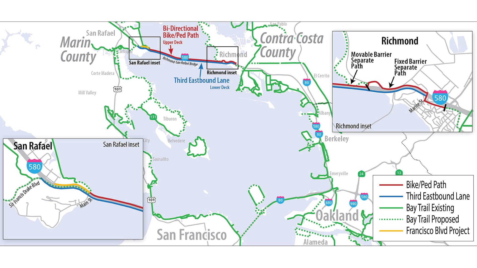
The bicycle and pedestrian path across the upper deck is a key part of the Bay Trail network.

2025-2028 Richmond-San Rafael Bridge Path Modified Pilot: New Hours of Operations
The bike/pedestrian path on the bridge will be open Thursdays from 2 p.m. through Sundays at 11 p.m,, with the exception of some state holidays.
A free bike shuttle will be provided 6 a.m. to 8 p.m. (Mondays through Wednesdays) and 6 a.m. through 2 p.m. (Thursdays). See more details on the Richmond-San Rafael Bridge Path webpage.
The bridge path may also be temporarily closed under certain conditions, such as maintenance activities, high winds/inclement weather, injury or accident response.
This is an extension of the original pilot project, up to the end of 2028.
2024-2025 East Francisco Blvd. Project: Widening the Path & Increasing Safety
The Shared-Use Gap Closure project along East Francisco Blvd. will widen approximately 2,000 feet of existing sidewalk to allow bi-directional bike and pedestrian travel to/from the Richmond-San Rafael Bridge and the flyover at the intersection of Grange Ave. in the City of San Rafael.
This project will also be realigning the East Francisco Blvd. roadway, will move an existing overhead utility line below ground and add additional signage and striping.
Construction Update: 2/18/2026
All driveway construction, paving and sidewalk work on the new 10-foot-wide bike and pedestrian path along Francisco Boulevard East between Grange Way and Main Street has been completed. The utility relocation to the new underground facilities was completed in December 2025 for all providers, including PG&E, AT&T, Comcast and Zayo. PG&E crews subsequently removed the abandoned overhead lines in December 2025. Remaining work – including finishing pavement trench repair and installation of signage and striping on Francisco Blvd. East between Grange Way and Main Street – is expected to be completed in the coming weeks, weather permitting. Businesses remain open during construction, and vehicle traffic will be possible in and out of the driveways. Vehicle traffic through the work zones is restricted to 25 MPH and drivers are reminded to share the road with bicyclists.
East Francisco Blvd. Project Staff Contact
Nafis Majd
Email: nmajd@bayareametro.gov
2018-2024 Completed Pilot Projects
Richmond-San Rafael Bridge users saw the benefits of these pilot projects completed by the Bay Area Toll Authority and partners:
- A third vehicle lane for peak use opened on the lower deck in 2018
- A six-mile bicycle/pedestrian path opened on the upper deck for public use in 2019, completing an important active transportation link in the Bay Trail between Marin and Contra Costa counties
- A project on the Sir Francis Drake offramp in 2020 added new striping, signage and safety improvements for cyclists
Pilot Study Report
Caltrans and UC Berkeley PATH have completed the Phase I and Phase II After Study for the Richmond-San Rafael Bridge Access Improvements Project.
Bicycle Safety on Sir Francis Drake
The Bay Area Toll Authority (BATA)’s latest Richmond-San Rafael Bridge project added multiple improvements to the Sir Francis Drake Boulevard offramp, including:
- A moveable barrier to protect cyclists from vehicles
- Improved signage
- Pavement striping
- Pavement markers
The new bikeway offers improved bicycle trail linkage to transportation hubs and commute destinations in southern Marin County, such as Sonoma-Marin Area Rapid Transit (SMART) Larkspur Station, Central Marin Ferry (Larkspur) Terminal, and the adjacent towns and cities.
The barrier protecting pedestrians and cyclists can be moved by a “zipper truck” to allow BATA and Caltrans to conduct nightly bridge maintenance. Each segment of the barrier weighs 1,500 pounds!

BATA worked in partnership with the California Department of Transportation, the Contra Costa Transportation Authority and the Transportation Authority of Marin to complete both the peak-period third lane on eastbound Interstate 580 and the bicycle/pedestrian path.
To save money and speed completion, BATA and its partners performed the required permitting and environmental work for both projects simultaneously.
Read the August 2016 Project Approval document.