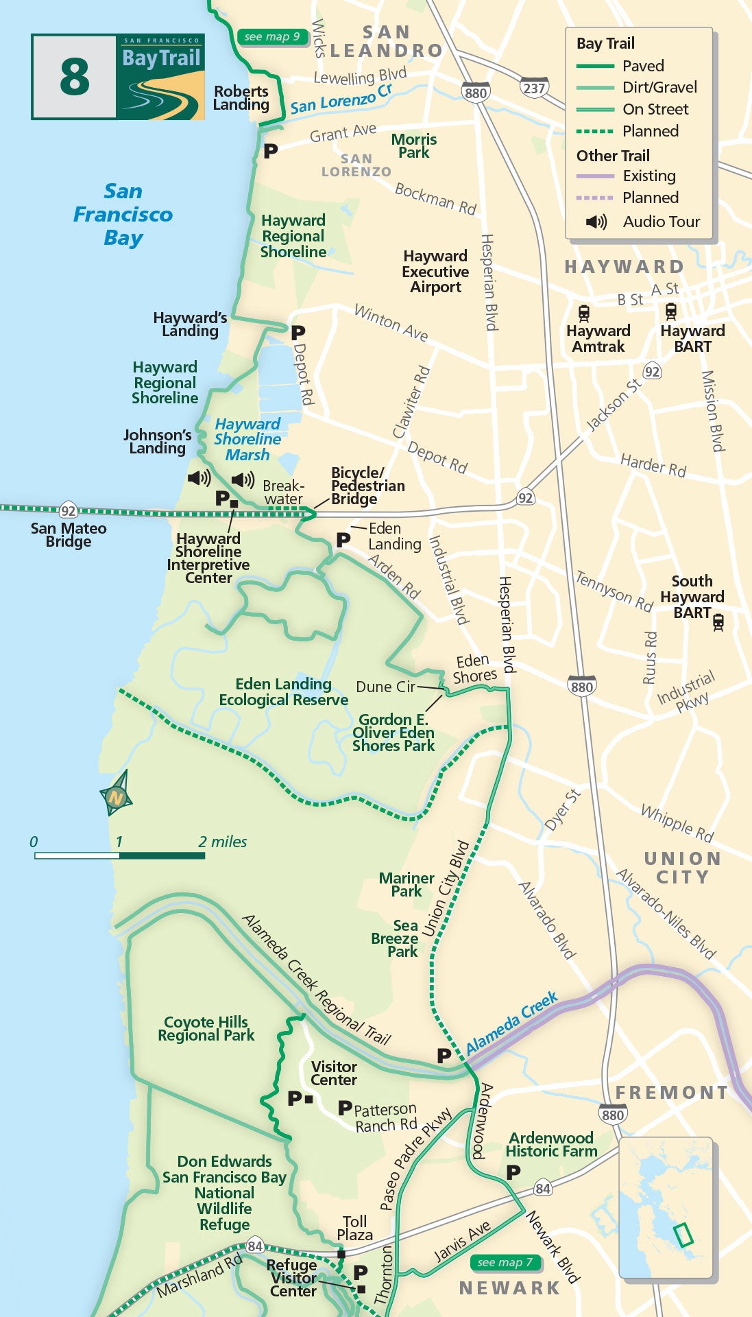
Map 8 — Newark to San Leandro
Coyote Hills
Visit the Don Edwards San Francisco Bay National Wildlife Refuge Headquarters and Visitor Center in Newark for exhibits describing endangered species and migratory birds, and a media room with videos on the refuge and the South Bay Salt Pond Restoration Project.
Cross over Highway 84 on a bicycle/pedestrian bridge above the toll plaza and head into Coyote Hills Regional Park to explore the maze of paved and natural-surface shoreline trails along the shallows of the bay and inland marshes.
The Coyote Hills Regional Park Visitor Center displays exhibits on the birds, wildlife and wetlands of the park. To reach Ardenwood Historic Farm, follow bike lanes along streets. Connect with the Alameda Creek Regional Trail, extending 12 miles from the bay to the foothills along the edge of Alameda Creek.
Eden Landing
Along the way, you’ll find picnic sites and fishing ponds. To reach Eden Landing Ecological Reserve, turn left on Eden Shores Boulevard. The entrance is off Dune Circle near the northwest corner of Gordon E. Oliver Eden Shores Park.
More than 600 acres of former salt ponds are being transformed into managed ponds and tidal wetlands in this area south of Highway 92 as part of the 15,100-acre South Bay Salt Pond Restoration Project.
Hayward Regional Shoreline
Cross over Highway 92 on a bicycle/pedestrian bridge and continue to the Hayward Regional Shoreline, stopping at the Hayward Shoreline Interpretive Center to view the art gallery and animal exhibits and learn about programs and activities designed to inspire a sense of appreciation, respect and stewardship for the bay.
The 1,713-acre Hayward Regional Shoreline provides habitat for hundreds of species of birds and other wildlife, including the endangered salt marsh harvest mouse. Between 1980 and 1991, 600 acres were transformed from fallow salt ponds into freshwater, brackish and saltwater marshes. As you travel north from the Hayward Shoreline, one of the longest continuous stretches of Bay Trail guides you into San Leandro, with bay wetlands accompanying you the entire way.
Alameda Creek Regional Trail/Coyote Hills, Fremont
This network of over 18 miles of Bay Trail along Alameda Creek and at Coyote Hills Regional Park provides ample opportunities to explore the scenic hills and shoreline in this area. Covered with wetlands and visited by many migrating birds, you get a sense of how truly wild the bay can be.
Hayward Regional Shoreline
This 1,811-acre shoreline park is a haven for over 200 bird species including egrets, herons, shorebirds and other waterfowl. Bring your binoculars and scopes out on the trail and enjoy the birds in these valuable wetlands during migration season.
Hayward Shoreline Interpretive Center
The Hayward Shoreline Interpretive Center provides an introduction to the ecology of the San Francisco Bay Estuary. It features exhibits, programs and activities designed to inspire a sense of appreciation, respect and stewardship for the bay, its inhabitants and the services they provide.

