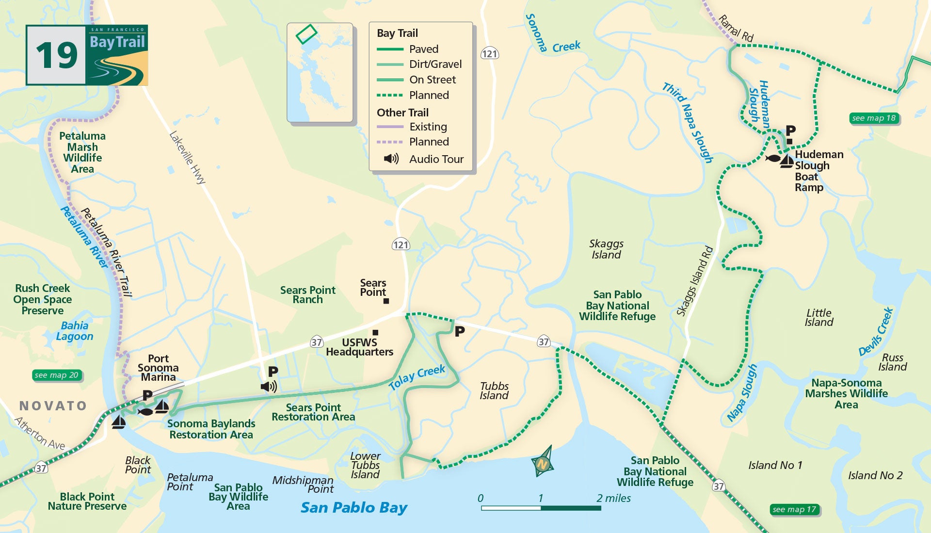
Map 19 — Hudeman Slough to Black Point
Rural Napa County
The northern end of San Pablo Bay is a vast expanse of marsh plain, sloughs, mudflats, egrets, herons, sandpipers, avocets and more.
But what about the trail? While this area represents the least complete portions of the Bay Trail system, the four segments currently open to the public — the Tubbs Island Trail, Sears Point Bay Trail (Elliot Trail), Sonoma Baylands Bay Trail and the Port Sonoma Marina Trail — are all spectacular and should not be missed.
The Tubbs Island Trail in Sonoma County can only be accessed from Highway 37 in the eastbound direction, as a solid barrier prevents access to westbound travelers. From the eastbound lane, look for the pull-out approximately 1/2 mile after the junction with Arnold Drive/Highway 121. There is parking here for approximately 8 vehicles. This 3-mile trail once formed a loop, but several levee breaches now make this an out-and-back journey.
The Tubbs Island Trail will take you to Midshipman Point on a levee-top, windswept, jackrabbit-laden trip to what feels like the ends of the earth. Please note that no dogs are allowed on the Tubbs Island trail.
Sonoma
Driving west on Highway 37, turn left at the Lakeville Highway/Reclamation Road signal and look for the public parking lot a few hundred yards ahead. A dirt path parallels a paved road heading south toward the Sears Point and Sonoma Baylands levees.
Once on the levee trail, head east for a 2.5-mile out-and-back (5 miles total) trek alongside a recently restored wetland-in-progress. Head west for a 1.5-mile walk or ride along the Sonoma Baylands marsh, created with clean dredged material from the Port of Oakland.
Nearly 3 million cubic yards of clean silt were removed from the Oakland harbor to create deepwater channels for shipping. What might have gone to waste at an ocean disposal site was instead put to beneficial use in this project to restore 322 acres of diked baylands to salt marsh. Nearly 20 years on, wetland vegetation has taken hold and abundant bird life abounds.
The Petaluma River Trail is a work in progress. While more trail currently exists at the northern end in downtown Petaluma, the trail will eventually reach the bay at Port Sonoma and connect to the Bay Trail.
All of these trails are natural surface, composed of compacted dirt or gravel.
Sonoma Baylands Trail (Petaluma)
A great ride or walk, this 1.5 mile segment is a great place for birding and for witnessing a wetland restoration in action. Park near Port Sonoma Marina and walk towards the bay.
Black Point Boat Launch (Novato)
This launch provides a perfect setting for paddlers and rowers to explore the Petaluma River and San Pablo Bay, while enjoying views of the surrounding hills and glimpses of wildlife.

