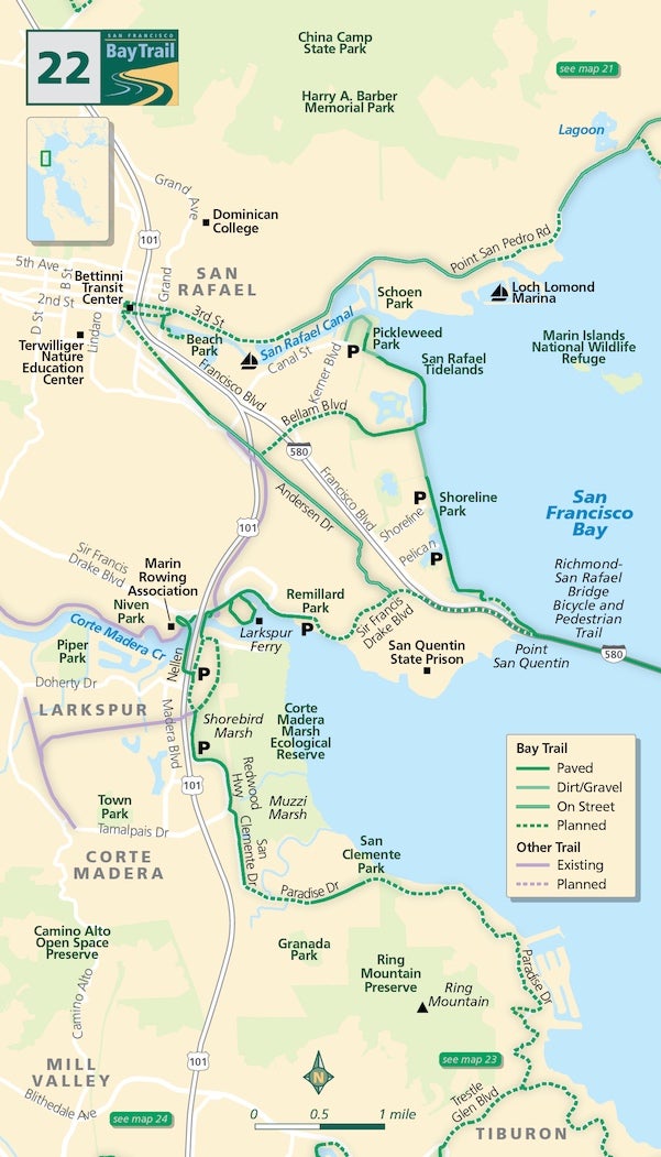
Map 22 — Central San Rafael to Corte Madera
San Rafael
With China Camp behind you, heading toward San Rafael on Point San Pedro Road can be a challenge as bike lanes and sidewalks are intermittent at best.
While a route along the San Rafael Canal has yet to materialize, a beautiful shoreline trail begins at Pickleweed Park at the intersection of Kerner and Canal Boulevards. This mostly paved 2.4-mile path runs south toward the Richmond-San Rafael Bridge through Shoreline Park. Great views of the Marin Islands National Wildlife Refuge — supporting the largest heron and egret rookery in the San Francisco Bay Area — can be had from this trail.
From downtown San Rafael, the Bay Trail heads southeast from the Bettini Transit Center. A new rail/trail associated with the SMART train will connect the transit center to the new SMART path that begins at Rice Drive, but for now, follow Francisco Boulevard West from the transit center to the path entrance at Rice.
Larkspur
At Andersen Drive, head east to stay on the Bay Trail (bike lanes, sidewalks), or continue straight to take the CalPark Hill Tunnel to Larkspur. To access the Bay Trail on the Richmond-San Rafael Bridge from this junction, please visit 511.org as improvements are currently underway in this complex area, and conditions are changing monthly. Also see Map #23 — Richmond-San Rafael Bridge.
To stay in Marin, head west on Sir Francis Drake Boulevard. While there is no shoreline path around San Quentin State Prison (surprise!), a lovely bayside path begins just west of the prison at Remillard Park in Larkspur. Don’t miss the spur that loops through the Larkspur Ferry parking lot with its unique views of the Corte Madera Creek.
Corte Madera
A new crossing of Corte Madera Creek is slated for completion by early 2022 as part of the Transportation Authority of Marin's North-South Greenway Gap Closure project, but for now, continue west parallel to Sir Francis Drake, take the boardwalk to your left and pass under the freeway.
Check out the rowing teams slicing through the waters of the Corte Madera Creek, but don’t forget to turn right before the Marin Rowing Association boathouse to gain access to the Bay Trail over the Creek (path adjacent to freeway).
Cross back to the east side of the freeway via the bike/pedestrian overcrossing and navigate the Bay Trail gap on Redwood Highway until you reach the shoreline path at Redwood and Wornum Drive. Sit a spell at Muzzi Marsh, a part of the Corte Madera Marsh Ecological Reserve — it’s a veritable bird-palooza!
Continuing south on Paradise Drive toward Tiburon is not recommended for pedestrians as there are no sidewalks and a minimal shoulder. This segment also is not recommended for inexperienced cyclists. It is, however, highly recommended for cyclists who are comfortable with rural winding roads, oak forests and stunning bay views.
Remillard Park (Larkspur)
A very, very, tall metal Sir Francis Drake sculpture presides over this narrow-but-lovely shoreline park across the channel from the Larkspur Ferry terminal. Be sure to take a stroll around the perimeter of the ferry parking lot while you’re here — great views come in surprising places.
Shoreline Park (San Rafael)
This 2.4-mile flat bayside path offers great views of the Richmond-San Rafael Bridge, the Marin Islands and Point San Pablo. The Shoreline Park Bay Trail connects via Francisco Boulevard to a new bicycle/pedestrian path on the Richmond-San Rafael Bridge, a long-desired connection between Marin and Contra Costa Counties.
Shoreline Park (San Rafael)
This 2.4-mile flat bayside path offers great views of the Richmond-San Rafael Bridge, the Marin Islands and Point San Pablo.

