Bay Trail SFO Gap Study
The Bay Trail SFO Gap Study identifies potential Bay Trail alignments to close the three-mile Bay Trail gap around San Francisco International Airport.
About the Bay Trail SFO Gap Study
The vision for the San Francisco Bay Trail is a continuous, 500-mile trail around San Francisco and San Pablo Bays that serves 47 cities in all nine Bay Area counties.
Today, there is a three-mile gap around San Francisco International Airport (SFO) and an opportunity for a new Bay Trail segment through Millbrae and San Bruno.
The Bay Trail SFO Gap Study Final Plan documents existing conditions and identifies potential new Bay Trail segments near SFO. The study also recommends a design for a future segment of the Bay Trail to close the gap in this area.
The 1998 San Francisco International Airport Bay Trail Alignment Plan (BTAP) developed a "preferred permanent alignment" of the San Francisco Bay Trail around SFO. This alignment, though not perfect, is one that can happen over time with ongoing stewardship, cooperation and sufficient funding.
The Bay Trail SFO Gap Study reevaluates potential alignments, including the 1998 BTAP, given the 25-year-gap since the completion of the 1998 BTAP and the lack of Bay Trail development occurring during this timeframe in this area.
Funding
This project is funded by a $160,000 donation from the John and Gwen Smart Foundation. Additional funding has been added to assist with environmental and right-of-way analysis.
Staff Contact
Diane Dohm
Phone: 415-778-4429
Email: DDohm@bayareametro.gov
This graphic shows existing portions of the Bay Trail (in green), as well as the area that will be reviewed in the Bay Trail SFO Gap Study (in red).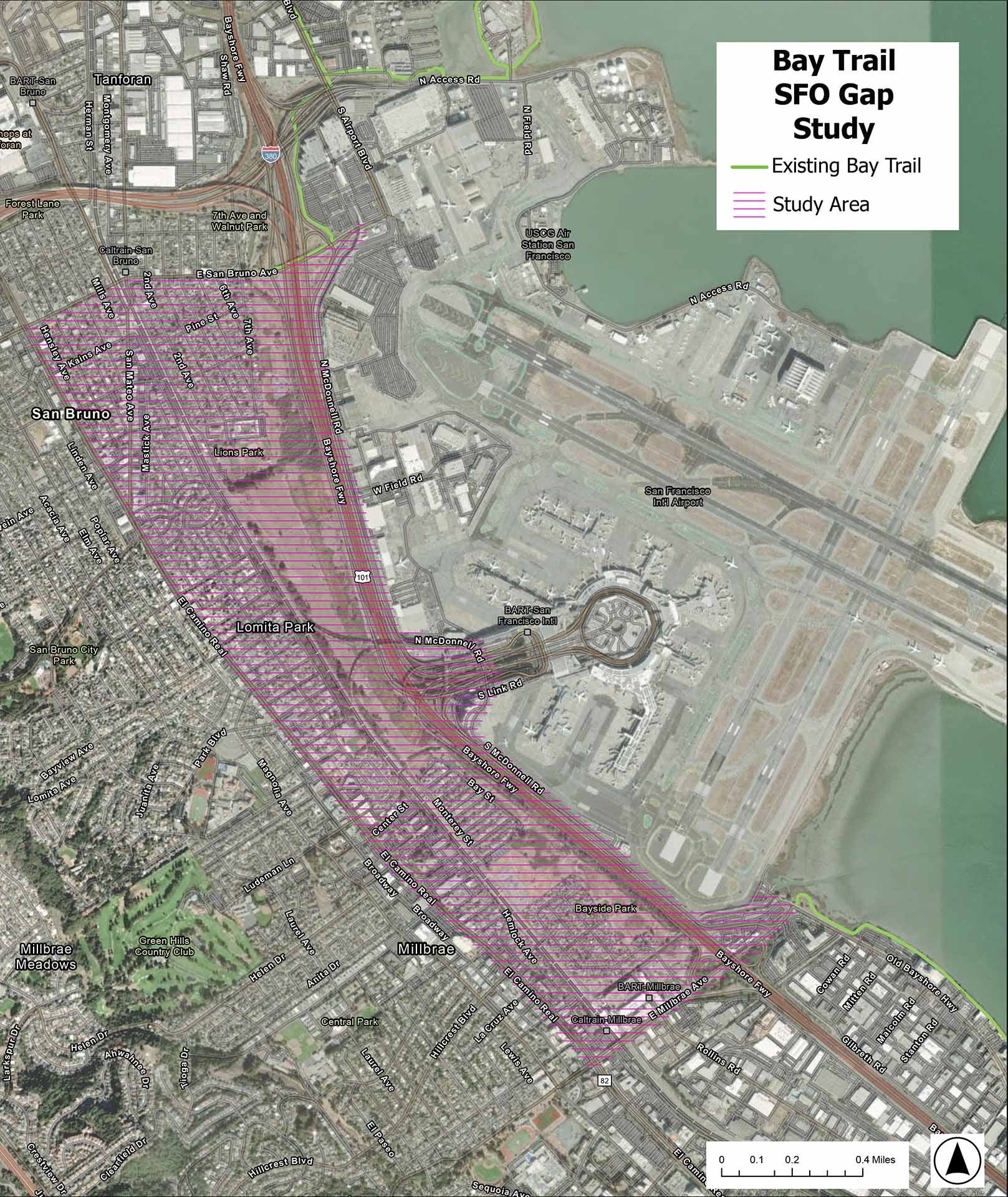

- Phase 1 Survey Results: The community submitted more than 1,500 survey responses, indicating "safety" and "comfort" as the most important criteria for a future route.
- Phase 2 Survey Results: The community submitted more than 1,100 survey responses. The "1998 Plan" option was the top-ranked trail route. Additionally, the "1998 Plan" option was indicated as the route that best meets Bay Trail goals.
- Phase 3 Survey Results: The community submitted more than 660 survey responses, indicating these design and trail support facilities as the most important: fencing or screening from the roadway, restrooms, trees and landscaping and pedestrian-oriented lighting.